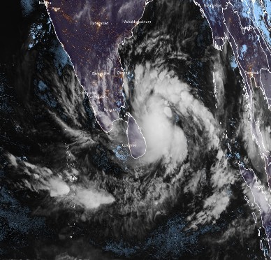
Sri Lanka braces for Cyclone Burevi
Red alert issued for most provinces
COLOMBO – The Department of Meteorology on Wednesday (2) issued ‘red alerts’ for most parts of the country for Wednesday (2) and Thursday (3), as Cyclone ‘Burevi’ moved closer to Sri Lanka, and was expected to reach the east coast by late evening or night on Wednesday.
The Met Department issuing the red alert for the Northern, North Central, Eastern, North Western, Western, Central and Sabaragamuwa Provinces, urged the public to be vigilant and fishermen to stay ashore, warning of strong, gusty winds of 80-100 kmph strength at times on both days and very heavy rainfall above 200 mm at some places with intermittent showers at others.
Noting that the cyclone lay centered near latitude about 240 km east-southeast of Trincomalee at 2:30 a.m. on Wednesday, the Department said the system was very likely to move west-northwestwards and cross the eastern coast of Sri Lanka between Batticaloa and Point-Pedro, close to Trincomalee later in the day (evening or night), with a wind speed of 75-85 kmph gusting up to 95 kmph. It forecast the cyclone was very likely to move nearly westwards thereafter, emerge into the Gulf of Mannar.
It also warned of a possible one-metre high storm surge above the astronomical tide would likely inundate low lying areas in the Eastern Province.
The Met Department said the centre of the storm was expected to be 10 kilometres off Trincomalee by 5:30 p.m. on Wednesday, with landfall expected at 11: 30 p.m. It warned naval and fishing communities not to venture to the sea areas around the island until further notice and urged those who are out at sea in the areas extending from Kankesanturai to Pottuvil and Trincomalee to return to the coast or move safer areas immediately.
The Met Department also warned of possible damage to huts, temporary shelters and light structures, destruction of roof tops with roofing sheets being blown off, damage to power and communication lines, uprooting of large trees and breaking of tree branches, damage to paddy crops, banana, papaya trees and orchards, damage to smaller vessels and yachts anchored in harbours, flash floods and sea water inundation in low lying areas in the near coast.
-ENCL


