

Deciphering Cyclone Ditwah that stayed and stayed and rained and rained
COLOMBO – Cyclone Ditwah was an unusual weather system that developed too close to Sri Lanka’s coast, intensified suddenly and lingered an extraordinarily long time over Sri Lanka, dumping massive volumes of water on the Indian Ocean island.
In the last 125 years, when 16 cyclones hit the island, Cyclone Ditwah stands out like a sore thumb, meteorologists say.
Late Development
Cyclones usually form far away in the Bay of Bengal, giving advance warning of a week or more in some cases as the weather systems move across the Bay of Bengal, says Ajith Wijemannage, Director at the Department of Meteorology.
Cyclones also don’t usually go from South to North, but across Sri Lanka.
After entering from the East Coast, or from South-East in some cases, weather systems move rapidly across the island, and usually exits from the North or Northwest of the island.
The 1978 Severe Cyclonic Storm entered Batticaloa around 6:30 p.m. and moved across the island overnight and exited into Gulf of Mannar by next morning.
The Ditwah system started as a tropical disturbance just South of Sri Lanka, though it was recognized that there was a possibility of it intensifying further.
Meteorologists classify weather systems in the Indian Ocean as tropical disturbances, depressions, deep depressions, cyclonic systems, severe cyclonic systems and super severe cyclones based mainly on sustained wind speeds.
Confounded
Initially the system gave confusing signals, and its path could not be predicted easily, says Shiromani Jayawardane, a climate researcher and former meteorologist at Sri Lanka’s Meteorological Department.
“Various models gave different results,” she says.
According to the Cyclone Advisory issued by the Regional Specialized Meteorological Centre (RSMC) in New Delhi, the ECMWM model (European Centre for Medium-Range Weather Forecasts) at 2330 hours on November 26 indicated that the system would skirt Sri Lanka.
It quoted other weather models as giving different results, though there was agreement that the system would intensify.
“NCEP GFS (National Centres for Environmental Prediction Global Forecast System) is indicating the system would intensify, move east-north-eastwards across Sri Lanka during next 72 hours with gradual intensification and emerge into southwest Bay of Bengal during subsequent 24 hours.
“NCUM model is indicating a low-pressure area over southwest Bay of Bengal off south Sri Lanka coast with initial eastward movement during next 24 hours.
“All models are in agreement of the intensification up to depression during the subsequent 24 hours and further intensification during subsequent 48 hour. The models exhibit large variability in the track and further intensification thereafter,” the advisory read.
RSMC New Delhi is in charge of issuing the final advisory for the Indian Ocean.
The World Meteorological Organization (WMO) and the Economic and Social Commission for Asia and the Pacific (ESCAP) jointly established the Panel on Tropical Cyclones (PTC) in 1972 to cover the Indian Ocean and the Arabian sea.
The PTC was a result of the Bhola cyclone that killed over 300,000 (some estimates suggest 500,000) mainly due to storm surges in Bangladesh (then East Pakistan). The Indian Met Office correctly predicted the cyclone, but Bangladesh was apparently caught by surprise.
If multiple countries give different advisories, air navigation across the region would also be difficult as pilots would be confused, Jayawardena pointed out.
Member countries therefore communicate with RSMC New Delhi through the PTC panel regularly.
Flood Warnings
Based on initial findings on the tropical disturbance, the Met Department had issued an advisory for heavy rains several days earlier, using the ECMWM model, which Sri Laka also uses.
Based on that Sri Lanka’s Department of Irrigation issued a pre-flood advisory dated 0900 hours on November 25.
“A developing low-pressure system in the vicinity of the South Andaman Sea, along with its potential intensification over the coming days, and the associated impacts, have been analyzed and forecast by the Department of Meteorology using European Centre for Medium-Range Weather Forecasts models,” the Early Advisory for Flood Preparedness noted.
“Accordingly, official advisories have been issued regarding the likelihood of very heavy rainfall exceeding 200 mm in the Northern, North Central, Eastern, Southern, Uva, and Western Provinces, as well as significant rainfall in other parts of the country.
“Relevant disaster management authorities are hereby requested to take all necessary preparedness and mitigation measures in response to the anticipated flood risk,” it said.
It is not clear how seriously people took the message.
As rains continued in Sri Lanka’s the Irrigation Department issued flood warnings for Yan Oya. Gal Oya. Heda Oya, Kumbukkan Oya, Maduru Oya, Mahaweli and Mundeni Aru on November 26.
At 2100 UTC, which is around 230 am on the November 27, the system was in Southwest Bay of Bengal and adjoining Sri Lanka coast near latitude 5.9°N and longitude 82.6°E, about 170 km east of Hambantota and 210 km south-southeast of Batticaloa.
“It is very likely to move nearly north-northwestwards across southwest Bay of Bengal, adjoining Sri Lanka and intensify further into a Deep Depression during next 12 hours,” the RSMC advisory said, noting, “Thereafter, it is very likely to intensify further and continue to move north-north-westwards across southwest Bay of Bengal & adjoining Sri Lanka coast towards North Tamil Nadu, Puducherry and adjoining south Andhra Pradesh coast during subsequent 48 hours.”
A firm path could not be predicted still, as different models were still giving different results, but all models showed that the system would intensify in a Deep Depression.
In the tropics between 5 north and 5 south latitudes, the so called cyclone doldrums, cyclones usually do not form, Jayawardena said.
The weather system was forming just in the Intertropical Tropical Convergence Zone barely 1 degree above 5, due to favourable conditions that had developed.
At the time there was another weather system across the Bay of Bengal: the degrading Senyar storm.
It is not clear whether there was any influence from Senyar that contributed to the peculiar conditions in which Ditwah developed.
At 5:30 am (0000 UTC), on November 27, the weather system was still not moving based on data collected three hours earlier. However, it was raining heavily in Sri Lanka.
The Depression was “practically stationery” at 5.9°N and longitude 82.5°E, about 160 km east of Hambantota and 220 km south-southeast of Batticaloa, the RSMC advisory said.
Intensifying to Cyclone
At 10:30 am on November 27, (430 UTC) the RSMC advisory said the weather system was moving, and issued the firm warning that the system was becoming a cyclone.
“The Depression over southwest Bay of Bengal and adjoining Sri Lanka coast moved north-north-westwards with a speed of 8 kmph during the past 6 hours, intensified into a Deep Depression and lay centred at 0000 UTC of today, the 27th November 2025 over the same region near latitude 6.3°N and longitude 82.4°E, about 150 km east of Hambantota (Sri Lanka) and 170 km south-southeast of Batticaloa (Sri Lanka).
“It is very likely to continue to move nearly north-north-westwards across southwest Bay of Bengal & adjoining Sri Lanka and intensify further into a cyclonic storm during the next 12 hours.”
A firm path was projected with multiple models giving similar results.
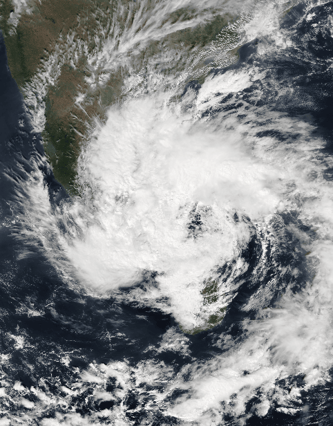
Cyclones usually lose intensity after landfall. However, Ditwah was continuing to draw moisture and dump water of up to 300 millimetres a day while moving over land.
Unlike many other cyclones, which zipped though the island in around half a day, Ditwah was moving very slowly at 5 to 8 kilometres over the island.
The slow movement was likely due to a high-pressure area over India which tended to push the system away, and slow it down, Wijemannage says.
The heaviest rainfall from cyclones or monsoons typically falls on the central mountains. As strong winds rise along the slopes, moisture condenses and turns into rain, a process known as the orographic effect, drenching the hill country.
Usually, because cyclones enter Sri Lanka from the East, the most intense rainfall is confined to the eastern flanks of the central hills.
This time, however, the deluge struck all sides of the hill country. Kandy and Gampola along the Mahaweli River, Kitulgala on the western slopes, and Badulla in the southeast were all hit simultaneously. Air was being drawn over the hills from multiple directions, producing unusually widespread orographic rainfall, a pattern that scientists say is not yet fully understood.
Cyclones that move up are very rare in Sri Lanka, one such occurred in 1931, Wijemannage said but it was centred offshore. Another one which moved up came to Sri Lanka around 1908.
Not a Severe Cyclone by Classification but Rained Slow Death
As cyclones go – at least under international classification system – Ditwah was not severe. With sustained winds below 89 kilometres it was a first level cyclone.
Severe Cyclones (SCS), Very Severe Cyclones and Super Severe Cyclones, have very high wind speeds.
The cyclone that hit Sri Lanka in 1978 with around 200 kilometre hour winds, was much more destructive, ripping apart roofs, decapitating vast swathes of coconut plantations, uprooting trees and causing destructive storm surges.
Compared to other cyclones there was less damage from falling trees.
Its destruction came from its slow movement, its path which fell close to the coast, without degrading, which brought sustained heavy rain over many days.
Ditwah moved slowly around 5 to 8 kilometres and it stayed and stayed and rained and rained for two days on a land that was already saturated from three days of rain before the weather system became a cyclone.
As a result, there were widespread landslides with deadly debris avalanches.
By December 4, there were 800 dead or missing from Cyclone Ditwah in Sri Lanka.
Compared to other regions, which see landfall by tropical storms, cyclones that make landfall are comparatively rare in Sri Lanka.
Bangladesh and India get hit with cyclones almost every year.
Vietnam was hit by the 15th typhoon this year with weary victims driven to shelters again and again. So far 409 people have died. Typhoons and depressions have hit 21 this year, up from the previous record of 20 set in 2017.
At the Bach Ma station in Thua Thien Hue, rainfall in October reached an extreme level of 1,739 mm in just 24 hours which could be a world record.
-economynext.com
Comments are closed, but trackbacks and pingbacks are open.